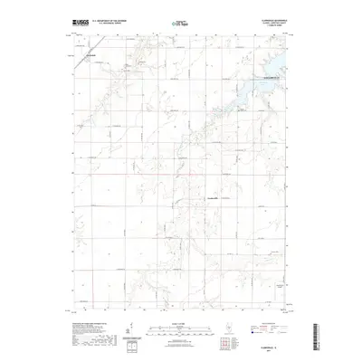
2021 Map of Clarksdale
USGS Topo · Published 2021About this map
Taylorville and its surrounding agricultural plains are defined by the meandering course of the S Fork Sangamon River and the artificial waters of Taylorville Lake. This region in Christian County reflects a landscape of organized section lines and rural homesteads, where small settlements like Clarksdale and Vanderville serve as local anchors. The map reveals a high density of family and community burial grounds, including Anderson Cem, Brush Creek Cem, and Mound Chapel Cem, which offer significant value for genealogists tracing local lineage. The drainage patterns of Cotton Cr and Brush Cr reveal the natural topography beneath the grid of county roads. Further south, the Kleinik RLA Airport marks a modern utility amidst the traditional farmsteads, while Lusters Lake provides a localized water feature within the Sangamon River's broader basin.
Find a feature on this map
37 named features on this map. Tap any name to fly to it.
Don’t see what you’re looking for? This feature index may not catch every label — zoom into the map to look around manually.
Map Details
Editions of this 2021 Clarksdale Map
This is the sole edition of this map. No revisions or reprints were ever made.
Other maps of this area

1923 · Taylorville
USGS Topo · 1:62,500

1925 · Taylorville
USGS Topo · 1:62,500

1946 · Nokomis
USGS Topo · 1:62,500

1947 · Pana
USGS Topo · 1:62,500

1949 · Nokomis
USGS Topo · 1:62,500

1949 · Pana
USGS Topo · 1:62,500

1952 · Assumption
USGS Topo · 1:62,500

1958 · Decatur
USGS Topo · 1:250,000

1961 · Decatur
USGS Topo · 1:250,000

1974 · Willeys
USGS Topo · 1:24,000