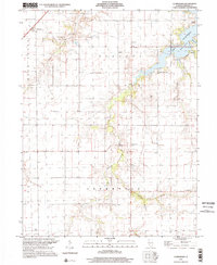
1998 Map of Clarksdale
USGS Topo · Published 2002About this map
The South Fork Sangamon River and its numerous tributaries, including Cotton Hill Creek and Brush Creek, define the topography of this central Illinois landscape. The 1990s character of the area is centered on the expansive waters of Lake Taylorville, where recreational developments like the Lake Shore Golf Club and various Picnic Areas have transformed the shoreline east of the city. Further south, the rural fabric remains intact, structured around early township boundaries like Johnson and Greenwood.
Find a feature on this map
22 named features on this map. Tap any name to fly to it.
Don’t see what you’re looking for? This feature index may not catch every label — zoom into the map to look around manually.
Map Details
Editions of this 1998 Clarksdale Map
This is the sole edition of this map. No revisions or reprints were ever made.
Other maps of this area

1923 · Taylorville
USGS Topo · 1:62,500

1925 · Taylorville
USGS Topo · 1:62,500

1946 · Nokomis
USGS Topo · 1:62,500

1947 · Pana
USGS Topo · 1:62,500

1949 · Nokomis
USGS Topo · 1:62,500

1949 · Pana
USGS Topo · 1:62,500

1952 · Assumption
USGS Topo · 1:62,500

1958 · Decatur
USGS Topo · 1:250,000

1961 · Decatur
USGS Topo · 1:250,000

1974 · Willeys
USGS Topo · 1:24,000