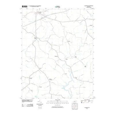
2010 Map of Clarkson
USGS Topo · Published 2010About this map
The Western Kentucky Pkwy cuts across the northern edge of this central Kentucky landscape, providing a modern corridor through a region defined by winding creek valleys and dispersed rural settlements. Clarkson serves as the primary hub in the north, while the southern reaches of the map are shaped by the irregular shoreline of Nolin Lake. The terrain is characterized by a dense network of watercourses including Bear Creek, Conoloway Creek, and Rock Creek, which dictate the placement of local roads and long-standing communities. Genealogists and local historians will find value in the documentation of family-named landmarks and resting places such as Logsdon Cemetery and Decker Cemetery. From the crossroads at Peonia to the small clusters at Snap and Meredith, the map illustrates a transition from agricultural uplands to the recreation-oriented landscape of Camp Loucon near the lake’s edge.
Find a feature on this map
65 named features on this map. Tap any name to fly to it.
Don’t see what you’re looking for? This feature index may not catch every label — zoom into the map to look around manually.
Map Details
Editions of this 2010 Clarkson Map
This is the sole edition of this map. No revisions or reprints were ever made.
Other maps of this area

1922 · Leitchfield
USGS Topo · 1:48,000

1925 · Cub Run
USGS Topo · 1:62,500

1925 · Leitchfield
USGS Topo · 1:62,500

1932 · Big Clifty
USGS Topo · 1:62,500

1949 · Summit
USGS Topo · 1:24,000

1949 · Big Clifty
USGS Topo · 1:24,000

1949 · Big Clifty
USGS Topo · 1:62,500

1953 · Bee Spring
USGS Topo · 1:24,000

1954 · Evansville
USGS Topo · 1:250,000
1954 · Dickeys Mills
USGS Topo · 1:24,000