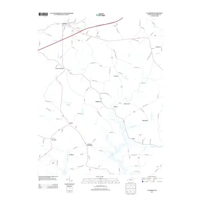
2013 Map of Clarkson
USGS Topo · Published 2013About this map
Clarkson serves as the primary hub in this central Kentucky region, situated north of the Western Kentucky Parkway. The landscape is defined by the winding course of Bear Creek and Rock Creek, which flow toward the significant waters of Nolin Lake in the south. This 2013 survey illustrates a rural network of small communities and crossroads such as Grayson Springs, Peonia, and Johnson Crossroads, linked by numerous named family roads like Annie Boone Rd and Jesse Skaggs Rd. For local historians and genealogists, the map identifies specific points of interest including Logsdon Cem and Decker Cem, alongside the recreational grounds of Camp Loucon. The transition from the developed streets of Clarkson to the dispersed settlements like Fragrant and Snap reflects the enduring agricultural and residential character of Grayson County.
Find a feature on this map
110 named features on this map. Tap any name to fly to it.
Don’t see what you’re looking for? This feature index may not catch every label — zoom into the map to look around manually.
Map Details
Editions of this 2013 Clarkson Map
This is the sole edition of this map. No revisions or reprints were ever made.
Other maps of this area

1922 · Leitchfield
USGS Topo · 1:48,000

1925 · Cub Run
USGS Topo · 1:62,500

1925 · Leitchfield
USGS Topo · 1:62,500

1932 · Big Clifty
USGS Topo · 1:62,500

1949 · Summit
USGS Topo · 1:24,000

1949 · Big Clifty
USGS Topo · 1:24,000

1949 · Big Clifty
USGS Topo · 1:62,500

1953 · Bee Spring
USGS Topo · 1:24,000

1954 · Evansville
USGS Topo · 1:250,000
1954 · Dickeys Mills
USGS Topo · 1:24,000