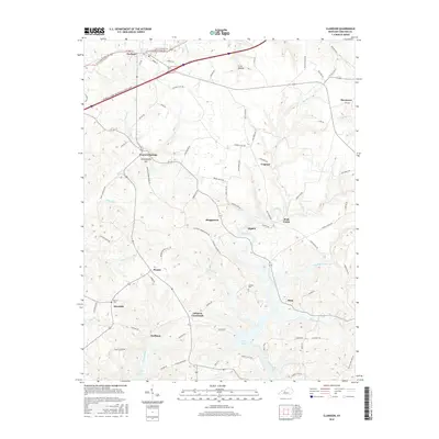
2016 Map of Clarkson
USGS Topo · Published 2016About this map
Clarkson and the surrounding Grayson County landscape are defined by a complex network of creeks and small rural settlements. The topography transitions from the flatter northern sections near Crow Hollow to the more dissected terrain around the Nolin Lake headwaters in the south. This area includes several notable family-named landmarks and local sites, such as Confederate Hill and the Logsdon Cem, which provide essential reference points for genealogists tracking local families. Transportation is anchored by the Wendell H Ford Western Kentucky Pkwy and a web of secondary roads like Saint Augustine Rd and Downs School Rd, which connect small communities including Peonia, Skaggstown, and Johnson Crossroads. The southern portion of the map highlights the recreational and hydrological impact of the Nolin Lake reservoir, where Conoloway Cr and Pearson Br feed into the larger water system.
Find a feature on this map
83 named features on this map. Tap any name to fly to it.
Don’t see what you’re looking for? This feature index may not catch every label — zoom into the map to look around manually.
Map Details
Editions of this 2016 Clarkson Map
This is the sole edition of this map. No revisions or reprints were ever made.
Other maps of this area

1922 · Leitchfield
USGS Topo · 1:48,000

1925 · Cub Run
USGS Topo · 1:62,500

1925 · Leitchfield
USGS Topo · 1:62,500

1932 · Big Clifty
USGS Topo · 1:62,500

1949 · Summit
USGS Topo · 1:24,000

1949 · Big Clifty
USGS Topo · 1:24,000

1949 · Big Clifty
USGS Topo · 1:62,500

1953 · Bee Spring
USGS Topo · 1:24,000

1954 · Evansville
USGS Topo · 1:250,000
1954 · Dickeys Mills
USGS Topo · 1:24,000