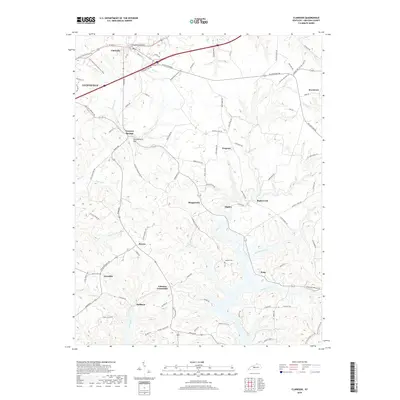
2019 Map of Clarkson
USGS Topo · Published 2019About this map
The town of Clarkson sits at the northern end of this central Kentucky landscape, where the road network branches out into the intricate drainage basins of Bear Cr and Rock Cr. This area is defined by a dense concentration of small communities and crossroads, including Grayson Springs, Peonia, and Johnson Crossroads, reflecting a deeply settled rural interior. The topography is notably complex, featuring landmarks such as Confederate Hill and the winding valleys of Grindstone Fork and Hunting Fork. Researchers of local family history will find several burial sites preserved on the map, such as Logsdon Cem and Decker Cem, which remain as anchor points for these unincorporated areas. The map also captures the outskirts of Leitchfield and the established boundaries of Indian Cliff Ests, showing how modern residential development and historic thoroughfares like Grayson Springs Rd have shaped the modern Grayson County landscape.
Find a feature on this map
96 named features on this map. Tap any name to fly to it.
Don’t see what you’re looking for? This feature index may not catch every label — zoom into the map to look around manually.
Map Details
Editions of this 2019 Clarkson Map
This is the sole edition of this map. No revisions or reprints were ever made.
Other maps of this area

1922 · Leitchfield
USGS Topo · 1:48,000

1925 · Cub Run
USGS Topo · 1:62,500

1925 · Leitchfield
USGS Topo · 1:62,500

1932 · Big Clifty
USGS Topo · 1:62,500

1949 · Summit
USGS Topo · 1:24,000

1949 · Big Clifty
USGS Topo · 1:24,000

1949 · Big Clifty
USGS Topo · 1:62,500

1953 · Bee Spring
USGS Topo · 1:24,000

1954 · Evansville
USGS Topo · 1:250,000
1954 · Dickeys Mills
USGS Topo · 1:24,000