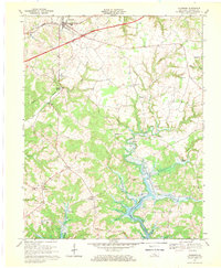
1967 Map of Clarkson
USGS Topo · Published 1969About this map
Grayson Springs and the surrounding Grayson County countryside are captured here in the late 1960s, a period marked by the modernization of rural Kentucky infrastructure. The Western Kentucky Parkway cuts a diagonal path across the northern landscape, contrasting with the older rail corridor of the Illinois Central near Clarkson. To the south, the recently established Nolin Reservoir has transformed the lower reaches of Rock Creek and Grindstone Creek, creating an intricate shoreline that follows the deep winding valleys. This map preserves a detailed view of traditional community centers like Peonia, Meredith, and Skaggstown before decades of further development. Local landmarks such as St Augustines Ch, Oak Grove Sch, and several cemeteries provide essential touchstones for genealogical research, while the presence of a Pipeline and Pumping Station indicates the expanding industrial footprint of the era.
Find a feature on this map
41 named features on this map. Tap any name to fly to it.
Don’t see what you’re looking for? This feature index may not catch every label — zoom into the map to look around manually.
Map Details
Editions of this 1967 Clarkson Map
This is the sole edition of this map. No revisions or reprints were ever made.
Other maps of this area

1922 · Leitchfield
USGS Topo · 1:48,000

1925 · Cub Run
USGS Topo · 1:62,500

1925 · Leitchfield
USGS Topo · 1:62,500

1932 · Big Clifty
USGS Topo · 1:62,500

1949 · Summit
USGS Topo · 1:24,000

1949 · Big Clifty
USGS Topo · 1:24,000

1949 · Big Clifty
USGS Topo · 1:62,500

1953 · Bee Spring
USGS Topo · 1:24,000

1954 · Evansville
USGS Topo · 1:250,000
1954 · Dickeys Mills
USGS Topo · 1:24,000