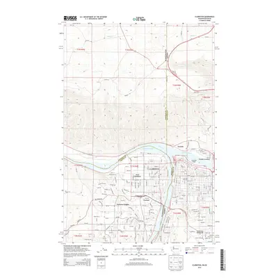
2014 Map of Clarkston
USGS Topo · Published 2014About this map
The Snake River and Clearwater River converge at the heart of this Pacific Northwest transition zone, where the state boundary between Washington and Idaho follows the river channel. The urban development of Clarkston and West Clarkston occupies the western bank, anchored by the residential expansion of Clarkston Heights and the older Vineland neighborhood near the Vineland Cem. Across the water, the Idaho side includes North Lewiston and the educational grounds of Lewis-Clark State Coll. To the north, the landscape rises steeply away from the river valley, marked by drainage features like Hatwai Cr and Spring Cr. This document records the intricate street grids of the early 21st century, from the industrial zones near the Transfer point and Port Way to the suburban layout of Lewiston Orchards near the local Airport Runway.
Find a feature on this map
61 named features on this map. Tap any name to fly to it.
Don’t see what you’re looking for? This feature index may not catch every label — zoom into the map to look around manually.
Map Details
Editions of this 2014 Clarkston Map
This is the sole edition of this map. No revisions or reprints were ever made.
Other maps of this area

1910 · Pullman
USGS Topo · 1:125,000

1945 · Clarkston
USGS Topo · 1:62,500

1948 · Clarkston
USGS Topo · 1:62,500

1955 · Pullman
USGS Topo · 1:250,000

1958 · Pullman
USGS Topo · 1:250,000

1958 · Lewiston Orchards North
USGS Topo · 1:24,000

1958 · Lewiston Orchards South
USGS Topo · 1:24,000

1958 · Lewiston Orchards
USGS Topo · 1:62,500

1961 · Moscow
USGS Topo · 1:62,500

1964 · Colton
USGS Topo · 1:24,000