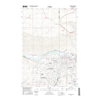
2017 Map of Clarkston
USGS Topo · Published 2017About this map
The confluence of the Snake River and Clearwater River serves as the central focal point of this region, marking the boundary between Washington and Idaho. The urban centers of Clarkston and Lewiston are intricately detailed, showing the expansion of residential and commercial districts into West Clarkston, Clarkston Heights, and Lewiston Orchards. The terrain transitions from the river valleys to the high plateaus, with the winding Old Spiral Hwy and Wawawai River Rd tracing the steep elevation changes. Educational and logistical infrastructure is prominent, including the Lewis-Clark State College campus and the sprawling grounds of the Lewiston-Nez Perce County Airport. Local history is anchored by sites such as the Vineland Cem, while the modern landscape is defined by the Lower Granite Lake reservoir and the Clearwater River Memorial Bridge.
Find a feature on this map
108 named features on this map. Tap any name to fly to it.
Don’t see what you’re looking for? This feature index may not catch every label — zoom into the map to look around manually.
Map Details
Editions of this 2017 Clarkston Map
This is the sole edition of this map. No revisions or reprints were ever made.
Other maps of this area

1910 · Pullman
USGS Topo · 1:125,000

1945 · Clarkston
USGS Topo · 1:62,500

1948 · Clarkston
USGS Topo · 1:62,500

1955 · Pullman
USGS Topo · 1:250,000

1958 · Pullman
USGS Topo · 1:250,000

1958 · Lewiston Orchards North
USGS Topo · 1:24,000

1958 · Lewiston Orchards South
USGS Topo · 1:24,000

1958 · Lewiston Orchards
USGS Topo · 1:62,500

1961 · Moscow
USGS Topo · 1:62,500

1964 · Colton
USGS Topo · 1:24,000