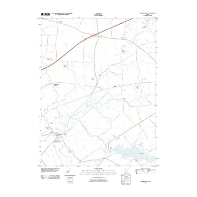
2010 Map of Clarksville
USGS Topo · Published 2010About this map
Clarksville serves as a central hub in this Warren County landscape, where the confluence of Todd Fork and the East Fork Todd Fork shapes the local topography. This 2010 survey highlights a deeply rooted social and agricultural fabric, evidenced by numerous burial grounds including the Quaker Cemetery, Jonahs Run Cemetery, and the Clarksville Independent Order of Odd Fellows Cemetery. The map documents a transition from traditional farming at Stonewall Farms and the Dale Stokes Raspberry Farm to recreational and managed water resources like Cowan Lake, which is contained by the Cowan Lake Dam. Smaller crossroads settlements such as Sligo, Ogden, and Hickoryville are interspersed throughout the township, connected by a network of rural routes that cross drainages like Lytle Creek and Jonahs Run.
Find a feature on this map
82 named features on this map. Tap any name to fly to it.
Don’t see what you’re looking for? This feature index may not catch every label — zoom into the map to look around manually.
Map Details
Editions of this 2010 Clarksville Map
This is the sole edition of this map. No revisions or reprints were ever made.
Other maps of this area

1907 · Blanchester
USGS Topo · 1:62,500

1913 · Waynesville
USGS Topo · 1:62,500

1914 · Morrow
USGS Topo · 1:62,500

1915 · Waynesville
USGS Topo · 1:62,500

1916 · Morrow
USGS Topo · 1:62,500

1917 · Xenia
USGS Topo · 1:62,500

1947 · Columbus
USGS Topo · 1:250,000

1953 · Cincinnati
USGS Topo · 1:250,000

1955 · New Burlington
USGS Topo · 1:24,000
1955 · Waynesville
USGS Topo · 1:24,000