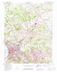
1957 Map of Clarksville
USGS Topo · Published 1981About this map
The Cumberland River and Red River define the geography of this mid-century survey, converging at the city center where industrial and civic infrastructure sits alongside long-standing neighborhoods. Civil development is anchored by Austin Peay State University and the Armory, while the Louisville and Nashville railroad provides the primary industrial artery. This edition includes significant purple-tinted updates from the 1970s, reflecting the suburban growth extending toward St Bethlehem and Ashland Hills. Beyond the urban core, the landscape is dotted with rural educational and spiritual landmarks, such as Needmore Sch and Oakland Ch. Geological and recreational interest is highlighted by Dunbar Cave and the waters of Lake Barkley, illustrating the balance between the region's natural karst topography and its engineered river systems.
Find a feature on this map
40 named features on this map. Tap any name to fly to it.
Don’t see what you’re looking for? This feature index may not catch every label — zoom into the map to look around manually.
Map Details
Editions of this 1957 Clarksville Map
3 editions found

Other maps of this area

1944 · Clarksville
USGS Topo · 1:50,000

1950 · Guthrie
USGS Topo · 1:24,000

1951 · New Providence
USGS Topo · 1:24,000

1951 · Hammacksville
USGS Topo · 1:24,000

1951 · Clarksville
USGS Topo · 1:24,000

1951 · Oak Grove
USGS Topo · 1:24,000

1956 · Nashville
USGS Topo · 1:250,000

1957 · Henrietta
USGS Topo · 1:24,000

1957 · Sango
USGS Topo · 1:24,000

1957 · New Providence
USGS Topo · 1:24,000
Featured Places
- Clarksville, TN
- Hillview Estates, Clarksville
- Shady Bluff, Clarksville
- Swan Lake Village, Clarksville
- Spring Valley, Clarksville