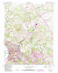
1957 Map of Clarksville
USGS Topo · Published 1984About this map
The confluence of the Cumberland River and Red River defines the landscape of Clarksville, Tennessee, at a mid-century period of significant expansion. The city's academic heart is anchored by Austin Peay State University, while the western edge transitions into the residential communities of New Providence and Ashland Hills. Of particular interest is the presence of Dunbar Cave State Park, encompassing Dunbar Lake and Dunbar Cave, which has served as a local focal point for generations. The 1984 update revisions, shown in purple, highlight the growth of suburban infrastructure and industrial footprints around St Bethlehem and the Seaboard rail line. Rural life remains visible through several neighborhood schools like Needmore Sch and Broomfield Sch, alongside numerous country churches including Oakland Ch and Spring Creek Ch.
Find a feature on this map
37 named features on this map. Tap any name to fly to it.
Don’t see what you’re looking for? This feature index may not catch every label — zoom into the map to look around manually.
Map Details
Editions of this 1957 Clarksville Map
3 editions found

Other maps of this area

1944 · Clarksville
USGS Topo · 1:50,000

1950 · Guthrie
USGS Topo · 1:24,000

1951 · New Providence
USGS Topo · 1:24,000

1951 · Hammacksville
USGS Topo · 1:24,000

1951 · Clarksville
USGS Topo · 1:24,000

1951 · Oak Grove
USGS Topo · 1:24,000

1956 · Nashville
USGS Topo · 1:250,000

1957 · Henrietta
USGS Topo · 1:24,000

1957 · Sango
USGS Topo · 1:24,000

1957 · New Providence
USGS Topo · 1:24,000
Featured Places
- Clarksville, TN
- Charlestown Estates, Clarksville
- Hillview Estates, Clarksville
- Shady Bluff, Clarksville
- Spring Valley, Clarksville