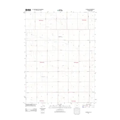
2013 Map of Clarkville SE
USGS Topo · Published 2013About this map
Pleasant Valley Methodist Church Cem stands as a central landmark in this high plains section of Yuma County, positioned near the intersection of Co Road 53 and Co Road P. The landscape is defined by the ephemeral winding of Rock Creek, which meanders through the northern sections, cutting through the geometric grid of agricultural section lines. This 2013 survey illustrates the enduring nature of the rectangular survey system in eastern Colorado, where the road network follows strict township and range boundaries such as t004n r047w and t005n r046w. The transition of local routes like Co Road M and Co Road S highlights the vast distances between rural settlements in this agricultural region.
Find a feature on this map
24 named features on this map. Tap any name to fly to it.
Don’t see what you’re looking for? This feature index may not catch every label — zoom into the map to look around manually.
Map Details
Editions of this 2013 Clarkville SE Map
This is the sole edition of this map. No revisions or reprints were ever made.
Other maps of this area

1954 · Sterling
USGS Topo · 1:250,000

1958 · Sterling
USGS Topo · 1:250,000

1971 · Fiddler Peak
USGS Topo · 1:24,000

1971 · Clarkville NE
USGS Topo · 1:24,000

1971 · Yuma NE
USGS Topo · 1:24,000

1971 · Clarkville SE
USGS Topo · 1:24,000

1971 · Old Baldy
USGS Topo · 1:24,000
1971 · Eckley NW
USGS Topo · 1:24,000

1972 · Clarkville
USGS Topo · 1:24,000

1972 · Clarkville SW
USGS Topo · 1:24,000