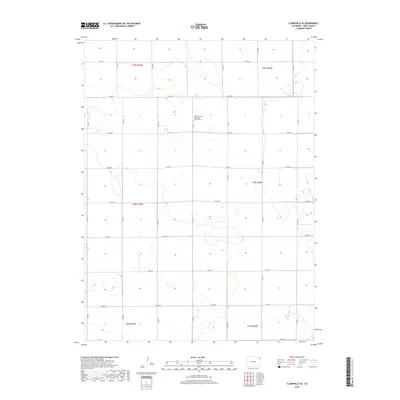
2019 Map of Clarkville SE
USGS Topo · Published 2019About this map
The High Plains of Yuma County are defined here by a geometric grid of rural routes, where Co Rd 54 and Co Rd 50 span the prairie between the Nebraska and Kansas borders. This agrarian landscape is anchored by the Pleasant Valley Methodist Church Cem, a vital point of interest for genealogists tracing early families in this corner of Colorado. The terrain is largely dominated by the drainage of Rock Cr., which meanders through the northwest, creating the only significant break in the otherwise orderly section lines of the Public Land Survey System. The map illustrates the 21st-century continuation of a settlement pattern established over a century ago, where life is organized around long-distance county roads and the seasonal flow of prairie creeks.
Find a feature on this map
25 named features on this map. Tap any name to fly to it.
Don’t see what you’re looking for? This feature index may not catch every label — zoom into the map to look around manually.
Map Details
Editions of this 2019 Clarkville SE Map
This is the sole edition of this map. No revisions or reprints were ever made.
Other maps of this area

1954 · Sterling
USGS Topo · 1:250,000

1958 · Sterling
USGS Topo · 1:250,000

1971 · Fiddler Peak
USGS Topo · 1:24,000

1971 · Clarkville NE
USGS Topo · 1:24,000

1971 · Yuma NE
USGS Topo · 1:24,000

1971 · Clarkville SE
USGS Topo · 1:24,000

1971 · Old Baldy
USGS Topo · 1:24,000
1971 · Eckley NW
USGS Topo · 1:24,000

1972 · Clarkville
USGS Topo · 1:24,000

1972 · Clarkville SW
USGS Topo · 1:24,000