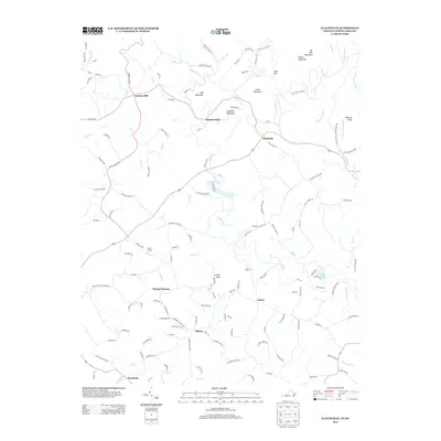
2013 Map of Claudville
USGS Topo · Published 2013About this map
Claudville and the surrounding rural communities sit at the foot of several prominent peaks in this 2013 survey of the borderlands between Virginia and North Carolina. The landscape is defined by the winding course of the Dan River, which flows through a region marked by agricultural legacy and small-scale industry. Geographic landmarks like Mill Mountain, Simmons Mountain, and Nunns Mountain rise above the valley, while the waters of Big Dan Lake and numerous creeks such as Archies Cr and Ararat River drain the terrain. Local history is evident in the naming of settlements and points of interest like Carters Mill, Meadowfield, and Circle R Farm. The map reveals a dense network of mountain roads and ridges, including Pedigo Ridge Rd and Short Ridge Rd, which connect established hubs like Asbury and Mount Herman to the more secluded reaches of Albion and Woodville.
Find a feature on this map
144 named features on this map. Tap any name to fly to it.
Don’t see what you’re looking for? This feature index may not catch every label — zoom into the map to look around manually.
Map Details
Editions of this 2013 Claudville Map
This is the sole edition of this map. No revisions or reprints were ever made.
Other maps of this area

1889 · Hillsville
USGS Topo · 1:125,000

1891 · Yadkinville
USGS Topo · 1:125,000

1892 · Hillsville
USGS Topo · 1:125,000

1893 · Yadkinville
USGS Topo · 1:125,000

1896 · Hillsville
USGS Topo · 1:125,000

1928 · Stuart
USGS Topo · 1:48,000

1931 · Stuart
USGS Topo · 1:62,500

1953 · Winston-Salem
USGS Topo · 1:250,000

1955 · Winston-Salem
USGS Topo · 1:250,000

1957 · Mount Airy
USGS Topo · 1:62,500