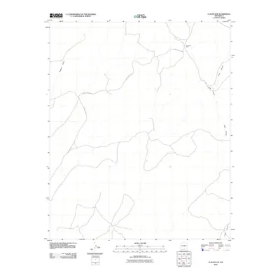
2010 Map of Claunch SE
USGS Topo · Published 2010About this map
Sloan Wells Camp serves as a lone human outpost in this arid stretch of Lincoln County, New Mexico, where the landscape is defined by the complex drainage systems of the high desert. The geography is characterized by deep erosional features including Pinatosa Canyon to the west and the winding course of Largo Canyon along the eastern boundary. This 2010 survey records a transition in the local infrastructure, with primary access provided by County Road A 020 and County Rd A017. These routes trace the natural contours of the land, connecting isolated ranching or monitoring sites like Sloan Wells Camp to the wider region. The map highlights the intersection of South Canyon and its tributaries, illustrating how water has shaped the rugged topography of this sparsely populated area.
Find a feature on this map
6 named features on this map. Tap any name to fly to it.
Don’t see what you’re looking for? This feature index may not catch every label — zoom into the map to look around manually.
Map Details
Editions of this 2010 Claunch SE Map
This is the sole edition of this map. No revisions or reprints were ever made.
Other maps of this area

1950 · Little Black Peak
USGS Topo · 1:62,500

1954 · Fort Sumner
USGS Topo · 1:250,000

1955 · Roswell
USGS Topo · 1:250,000

1958 · Fort Sumner
USGS Topo · 1:250,000

1958 · Roswell
USGS Topo · 1:250,000

1962 · Roswell
USGS Topo · 1:250,000

1973 · Ancho
USGS Topo · 1:24,000

1980 · Corona
USGS Topo · 1:100,000

1981 · Rough Mountain
USGS Topo · 1:24,000
1981 · Polecat Draw
USGS Topo · 1:24,000