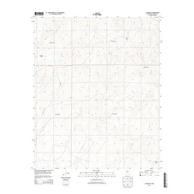
2013 Map of Claunch SE
USGS Topo · Published 2013About this map
Sloan Wells Camp sits near the divide between major drainage systems in this arid stretch of Lincoln County, highlighting the sparse, strategic settlement patterns typical of central New Mexico. The landscape is defined by its dramatic topographic relief, carved by the deep Pinatosa Canyon to the west and South Canyon in the northeast. These canyons, along with Largo Canyon at the southern edge, dictate the corridor of travel through the region. This 2013 survey by the U.S. Geological Survey documents the remote road network, specifically CO Road A020 and CO Road A017, which provide the only managed access across the rugged township and range lines of the Public Land Survey System. The map captures a moment in time where ranching infrastructure and geography intersect in a high-elevation desert environment.
Find a feature on this map
10 named features on this map. Tap any name to fly to it.
Don’t see what you’re looking for? This feature index may not catch every label — zoom into the map to look around manually.
Map Details
Editions of this 2013 Claunch SE Map
This is the sole edition of this map. No revisions or reprints were ever made.
Other maps of this area

1950 · Little Black Peak
USGS Topo · 1:62,500

1954 · Fort Sumner
USGS Topo · 1:250,000

1955 · Roswell
USGS Topo · 1:250,000

1958 · Fort Sumner
USGS Topo · 1:250,000

1958 · Roswell
USGS Topo · 1:250,000

1962 · Roswell
USGS Topo · 1:250,000

1973 · Ancho
USGS Topo · 1:24,000

1980 · Corona
USGS Topo · 1:100,000

1981 · Rough Mountain
USGS Topo · 1:24,000
1981 · Polecat Draw
USGS Topo · 1:24,000