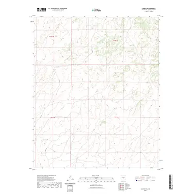
2023 Map of Claunch SE
USGS Topo · Published 2023About this map
South Canyon defines the northeastern terrain of this Lincoln County survey, providing a natural drainage point for the high desert landscape. The map details a network of ranching and utility routes that traverse the open country, including Tin Cup Rd and the aptly named Windmill Rd, which hint at the region's agricultural and water-management history. These unpaved arteries, alongside Bar L Trl, connect various sections of the Public Land Survey System, specifically townships t2s r10e through t3s r11e. The layout of these roads and trails suggests a landscape dedicated to large-scale land holdings and grazing, where travel is dictated by the subtle rise and fall of the arid topography near the northern Lincoln County boundary.
Find a feature on this map
11 named features on this map. Tap any name to fly to it.
Don’t see what you’re looking for? This feature index may not catch every label — zoom into the map to look around manually.
Map Details
Editions of this 2023 Claunch SE Map
This is the sole edition of this map. No revisions or reprints were ever made.
Other maps of this area

1950 · Little Black Peak
USGS Topo · 1:62,500

1954 · Fort Sumner
USGS Topo · 1:250,000

1955 · Roswell
USGS Topo · 1:250,000

1958 · Fort Sumner
USGS Topo · 1:250,000

1958 · Roswell
USGS Topo · 1:250,000

1962 · Roswell
USGS Topo · 1:250,000

1973 · Ancho
USGS Topo · 1:24,000

1980 · Corona
USGS Topo · 1:100,000

1981 · Rough Mountain
USGS Topo · 1:24,000
1981 · Polecat Draw
USGS Topo · 1:24,000