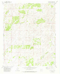
1981 Map of Claunch SE
USGS Topo · Published 1981About this map
Jones Well and Rock House Well stand as vital water sources in this high-desert landscape of Lincoln County during the mid-1970s. The terrain is defined by a series of significant drainage systems, most notably the winding course of Pinatosa Canyon in the northwest and the expansive Largo Canyon reaching through the eastern portion of the quadrangle. These features, along with South Largo Canyon, indicate a landscape where seasonal water flow and livestock ranching shaped human activity. The map reveals a sparse network of unimproved roads and fence lines, reflecting a period of traditional land use in central New Mexico. This survey, based on 1973 aerial photography and 1975 field checks, captures the topography before significant modern development, preserving the locations of isolated wells and named geological formations essential to local history.
Find a feature on this map
5 named features on this map. Tap any name to fly to it.
Don’t see what you’re looking for? This feature index may not catch every label — zoom into the map to look around manually.
Map Details
Editions of this 1981 Claunch SE Map
This is the sole edition of this map. No revisions or reprints were ever made.
Other maps of this area

1950 · Little Black Peak
USGS Topo · 1:62,500

1954 · Fort Sumner
USGS Topo · 1:250,000

1955 · Roswell
USGS Topo · 1:250,000

1958 · Fort Sumner
USGS Topo · 1:250,000

1958 · Roswell
USGS Topo · 1:250,000

1962 · Roswell
USGS Topo · 1:250,000

1973 · Ancho
USGS Topo · 1:24,000

1980 · Corona
USGS Topo · 1:100,000

1981 · Rough Mountain
USGS Topo · 1:24,000
1981 · Polecat Draw
USGS Topo · 1:24,000