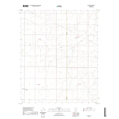
2020 Map of Claunch
USGS Topo · Published 2020About this map
The settlement of Claunch serves as the primary focal point of this 2020 landscape, situated at the boundary of Socorro Co and Lincoln Co. This high-desert terrain is defined by dry washes and strategic water improvements like Victor Tank, which are essential features in this arid environment. The map details a transition from the level flats near the townsite to the rising elevation of Rough Mtn in the northeast. Transportation and infrastructure are central to the area's layout, marked by the long stretch of Pipeline Rd and a network of county routes including Co Rd 208 and Co Rd A206. To the southeast, the land is scored by natural drainage features such as Sacate Draw, illustrating the hydrological patterns of the central New Mexico plains.
Find a feature on this map
16 named features on this map. Tap any name to fly to it.
Don’t see what you’re looking for? This feature index may not catch every label — zoom into the map to look around manually.
Map Details
Editions of this 2020 Claunch Map
This is the sole edition of this map. No revisions or reprints were ever made.
Other maps of this area

1954 · Fort Sumner
USGS Topo · 1:250,000

1954 · Socorro
USGS Topo · 1:250,000

1958 · Socorro
USGS Topo · 1:250,000

1958 · Fort Sumner
USGS Topo · 1:250,000

1962 · Socorro
USGS Topo · 1:250,000

1972 · Gran Quivira
USGS Topo · 1:24,000
1972 · Cat Mesa
USGS Topo · 1:24,000
1972 · Turkey Ridge NE
USGS Topo · 1:24,000
1979 · Socorro
USGS Topo · 1:100,000

1980 · Corona
USGS Topo · 1:100,000