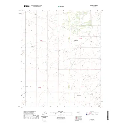
2023 Map of Claunch
USGS Topo · Published 2023About this map
Claunch sits at a crossroads in the high desert, anchoring a landscape defined by seasonal watercourses and the boundary between Socorro and Lincoln counties. The settlement is supported by local infrastructure including Wade Rd and Horse Bit Ln, while the nearby Claunch Cem provides a primary point of interest for genealogists tracing the history of this rural community. The surrounding terrain is marked by significant drainage features such as Polecat Draw, No Name Draw, and Sacate Draw, which cut through the arid plains. Notable landmarks like Rough Mountain and the water source at Victor Tank illustrate the challenges of ranching and survival in this New Mexico environment. The survey captures the modern road network, including several county routes and a prominent Pipeline Rd, indicating the intersection of traditional land use and contemporary infrastructure.
Find a feature on this map
19 named features on this map. Tap any name to fly to it.
Don’t see what you’re looking for? This feature index may not catch every label — zoom into the map to look around manually.
Map Details
Editions of this 2023 Claunch Map
This is the sole edition of this map. No revisions or reprints were ever made.
Other maps of this area

1954 · Fort Sumner
USGS Topo · 1:250,000

1954 · Socorro
USGS Topo · 1:250,000

1958 · Socorro
USGS Topo · 1:250,000

1958 · Fort Sumner
USGS Topo · 1:250,000

1962 · Socorro
USGS Topo · 1:250,000

1972 · Gran Quivira
USGS Topo · 1:24,000
1972 · Cat Mesa
USGS Topo · 1:24,000
1972 · Turkey Ridge NE
USGS Topo · 1:24,000
1979 · Socorro
USGS Topo · 1:100,000

1980 · Corona
USGS Topo · 1:100,000