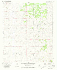
1981 Map of Claunch
USGS Topo · Published 1981About this map
Claunch sits on the high plains of New Mexico's interior, serving as a focal point for this expansive rangeland environment. The landscape is defined by its water management infrastructure, where several named storage features such as Crabtree Tank, Victor Tank, and Maxine Tank dot the terrain, alongside scattered Well sites and a Water Tank. These improvements underscore the region's reliance on groundwater and seasonal catchment to support cattle ranching in an arid climate.
Find a feature on this map
11 named features on this map. Tap any name to fly to it.
Don’t see what you’re looking for? This feature index may not catch every label — zoom into the map to look around manually.
Map Details
Editions of this 1981 Claunch Map
This is the sole edition of this map. No revisions or reprints were ever made.
Other maps of this area

1954 · Fort Sumner
USGS Topo · 1:250,000

1954 · Socorro
USGS Topo · 1:250,000

1958 · Socorro
USGS Topo · 1:250,000

1958 · Fort Sumner
USGS Topo · 1:250,000

1962 · Socorro
USGS Topo · 1:250,000

1972 · Gran Quivira
USGS Topo · 1:24,000
1972 · Cat Mesa
USGS Topo · 1:24,000
1972 · Turkey Ridge NE
USGS Topo · 1:24,000
1979 · Socorro
USGS Topo · 1:100,000

1980 · Corona
USGS Topo · 1:100,000