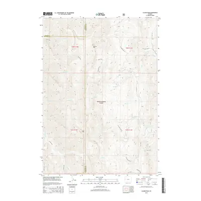
2015 Map of Clause Peak
USGS Topo · Published 2015About this map
Clause Peak and Ramshorn Peak dominate this high-elevation landscape within the Teton National Forest, where the borders of Teton, Sublette, and Lincoln counties meet. The map reveals a complex network of high-country drainages, including the headwaters of Fullturn Cr and Halfturn Cr which flow westward, while Clause Cr and Sandy Marshall Cr contribute to the Cliff Creek system on the eastern slopes. A distinct geographic feature known as Horse Heaven occupies the southwestern corner of the quadrangle. Human infrastructure is minimal in this wilderness area, centered primarily on the corridor of Cliff Creek Rd and the Cliff Creek Parallel road, which provide the only primary access points through these mountain ranges. The detailed topography illustrates the intricate ridgelines and steep canyons that have historically limited development to seasonal grazing and outdoor recreation.
Find a feature on this map
30 named features on this map. Tap any name to fly to it.
Don’t see what you’re looking for? This feature index may not catch every label — zoom into the map to look around manually.
Map Details
Editions of this 2015 Clause Peak Map
This is the sole edition of this map. No revisions or reprints were ever made.
Other maps of this area

1907 · Gros Ventre
USGS Topo · 1:125,000

1910 · Gros Ventre
USGS Topo · 1:125,000

1931 · Jackson
USGS Topo · 1:125,000

1935 · Jackson
USGS Topo · 1:125,000

1955 · Driggs
USGS Topo · 1:250,000

1958 · Driggs
USGS Topo · 1:250,000

1962 · Driggs
USGS Topo · 1:250,000

1965 · Pickle Pass
USGS Topo · 1:24,000

1965 · Camp Davis
USGS Topo · 1:24,000
1965 · Bailey Lake
USGS Topo · 1:24,000