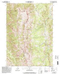
1996 Map of Clause Peak
USGS Topo · Published 1998About this map
The high peaks and drainages of the Teton National Forest are meticulously detailed in this mid-1990s survey, which marks the convergence of Sublette, Lincoln, and Teton counties. Dominating the central and southern elevations are Clause Peak and Ramshorn Peak, towering over a network of tributaries including Cliff Creek and Sandy Marshall Creek. The landscape is characterized by the complex management boundaries of the Jackson Big Piney Ranger District, where the terrain drops steeply into various creek beds like Kerr Creek and Bondurant Creek. This edition is particularly useful for tracking the precise county lines and water courses through the forest before modern digital revisions, providing a clear view of the natural water distribution across the high Wyoming wilderness.
Find a feature on this map
20 named features on this map. Tap any name to fly to it.
Don’t see what you’re looking for? This feature index may not catch every label — zoom into the map to look around manually.
Map Details
Editions of this 1996 Clause Peak Map
This is the sole edition of this map. No revisions or reprints were ever made.
Other maps of this area

1907 · Gros Ventre
USGS Topo · 1:125,000

1910 · Gros Ventre
USGS Topo · 1:125,000

1931 · Jackson
USGS Topo · 1:125,000

1935 · Jackson
USGS Topo · 1:125,000

1955 · Driggs
USGS Topo · 1:250,000

1958 · Driggs
USGS Topo · 1:250,000

1962 · Driggs
USGS Topo · 1:250,000

1965 · Pickle Pass
USGS Topo · 1:24,000

1965 · Camp Davis
USGS Topo · 1:24,000
1965 · Bailey Lake
USGS Topo · 1:24,000