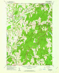
1960 Map of Claverack
USGS Topo · Published 1962About this map
Claverack Creek and Hollowville Creek define the landscape of central Columbia County in the early 1960s, winding through a region where agriculture and early suburban developments meet. The village of Claverack sits at a historic crossroads in the northwest, while the industrial and residential cluster of Philmont overlooks High Falls and several mill ponds to the northeast. Transportation patterns are dominated by the sweep of the Taconic State Parkway cutting north-south, and the New York Central Railroad corridor serving the northern settlements.
Find a feature on this map
55 named features on this map. Tap any name to fly to it.
Don’t see what you’re looking for? This feature index may not catch every label — zoom into the map to look around manually.
Map Details
Editions of this 1960 Claverack Map
4 editions found
Other maps of this area

1893 · Coxsackie
USGS Topo · 1:62,500

1894 · Coxsackie
USGS Topo · 1:62,500

1895 · Catskill
USGS Topo · 1:62,500

1902 · Copake
USGS Topo · 1:62,500

1903 · Kinderhook
USGS Topo · 1:62,500

1904 · Copake
USGS Topo · 1:62,500

1929 · Coxsackie
USGS Topo · 1:62,500

1933 · Kinderhook
USGS Topo · 1:62,500

1934 · Catskill
USGS Topo · 1:62,500

1938 · Catskill
USGS Topo · 1:62,500