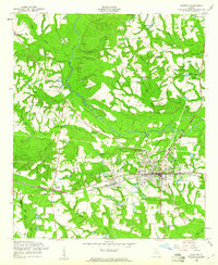
1958 Map of Claxton
USGS Topo · Published 1961About this map
Claxton and its neighboring communities of Hagan and Bellville define the populated center of this late 1950s landscape, situated along the Seaboard Line railroad. The regional importance of the timber industry is evident through the presence of the Evans County Forestry Unit, a prominent Lookout Tower, and local Sawmill operations. The social fabric of the era is marked by institutions like the Evans County High School and several rural churches, including Sikes Chapel and Zion Hill Ch. Beyond the towns, the terrain is characterized by a high density of private and community ponds, such as Shuman Pond and Perrys Pond, which dot the drainages of the Canoochee River. Genealogists will find significant value in the documentation of family-named burial grounds like Eason Cem and Hodges Cem.
Find a feature on this map
52 named features on this map. Tap any name to fly to it.
Don’t see what you’re looking for? This feature index may not catch every label — zoom into the map to look around manually.
Map Details
Editions of this 1958 Claxton Map
2 editions found
Other maps of this area

1919 · Claxton
USGS Topo · 1:62,500

1920 · Statesboro
USGS Topo · 1:62,500

1943 · Statesboro
USGS Topo · 1:62,500

1944 · Claxton
USGS Topo · 1:62,500

1947 · Savannah
USGS Topo · 1:250,000

1948 · Savannah
USGS Topo · 1:250,000

1950 · Claxton
USGS Topo · 1:62,500

1957 · Macon
USGS Topo · 1:250,000

1957 · Savannah
USGS Topo · 1:250,000

1958 · Macon
USGS Topo · 1:250,000