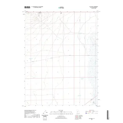
2020 Map of Clay Knoll
USGS Topo · Published 2020About this map
The Little Drum Mountains define the northern reaches of this Millard County landscape, giving way to an arid basin marked by a complex system of water management. The terrain transitions from the heights of the mountains and Chalk Knolls down to the eastern flats where the Old River Bed winds through the valley. This 2020 survey reveals a network of isolated water sources essential for livestock or land management in the West, including the W Marshall Tract Reservoir and the Hinckley Trail Reservoir. Historical transportation routes are preserved here in the form of Old 6 & 50, which cuts through the central plains. Near the southern boundary, Clay Knoll stands as a distinct landmark alongside a series of named catchments like the N Clay Knoll Reservoir and Clay Knoll Reservoir, illustrating the continued importance of water infrastructure in this high-desert environment.
Find a feature on this map
13 named features on this map. Tap any name to fly to it.
Don’t see what you’re looking for? This feature index may not catch every label — zoom into the map to look around manually.
Map Details
Editions of this 2020 Clay Knoll Map
This is the sole edition of this map. No revisions or reprints were ever made.
Other maps of this area

1885 · Sevier Desert
USGS Topo · 1:250,000

1908 · Fish Springs
USGS Topo · 1:250,000

1910 · Fish Springs
USGS Topo · 1:250,000

1953 · Delta
USGS Topo · 1:250,000

1958 · Delta
USGS Topo · 1:250,000

1962 · Delta
USGS Topo · 1:250,000

1971 · Smelter Knolls East
USGS Topo · 1:24,000

1971 · Clay Knoll
USGS Topo · 1:24,000

1971 · Rocky Knoll
USGS Topo · 1:24,000
1971 · Pot Mountain
USGS Topo · 1:24,000