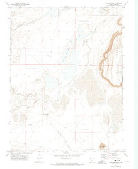
1971 Map of Pot Mountain
USGS Topo · Published 1974About this map
Pot Mountain anchors the southeastern corner of this arid landscape, overlooking a complex hydrological system where the Sevier River and Beaver River navigate a series of depressions and old channels. The terrain is characterized by high-desert features such as the Swan Lake Salt Marsh and several basins simply labeled as Depression, indicating the internal drainage patterns typical of this part of Millard County. Significant for local history and water rights, the map identifies specific water sources like the Headquarters Well and Jensen Spring, which were vital for life in this dry environment. Near the southern edge, a single Grave and a Dry Well serve as quiet markers of past human activity, while the massive Black Rock formation dominates the eastern boundary, illustrating the area's volcanic geological history.
Find a feature on this map
19 named features on this map. Tap any name to fly to it.
Don’t see what you’re looking for? This feature index may not catch every label — zoom into the map to look around manually.
Map Details
Editions of this 1971 Pot Mountain Map
This is the sole edition of this map. No revisions or reprints were ever made.
Other maps of this area

1885 · Sevier Desert
USGS Topo · 1:250,000

1953 · Delta
USGS Topo · 1:250,000

1958 · Delta
USGS Topo · 1:250,000

1962 · Delta
USGS Topo · 1:250,000

1962 · Delta
USGS Topo · 1:62,500

1971 · Red Pass
USGS Topo · 1:24,000

1971 · Clay Knoll
USGS Topo · 1:24,000

1971 · Rocky Knoll
USGS Topo · 1:24,000

1971 · Neels
USGS Topo · 1:24,000

1971 · Sunstone Knoll
USGS Topo · 1:24,000