
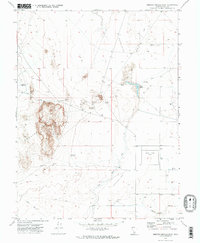
1971 Map of Smelter Knolls East
USGS Topo · Published 1974About this map
Topaz Camp (Site) stands as a significant historical footprint on this 1970s landscape in Millard County, marking the location of the former internment center. The surrounding terrain is defined by the stark topography of the Smelter Knolls and the prominent ridge known as Hogs Back. Water management in this arid Great Basin environment is evident through features like the Abraham Reservoir, the Abraham Canal, and Topaz Slough. The area's geological and industrial character is further noted by several Borrow Pit locations, Gravel Pits, and a Mine tucked into the knolls. Traces of the ancient landscape remain visible in the Old River Bed Depression, while a network of Jeep Trails provides the primary means of navigating the desert flats and muddy lowlands of the Mud flats.
Find a feature on this map
17 named features on this map. Tap any name to fly to it.
Don’t see what you’re looking for? This feature index may not catch every label — zoom into the map to look around manually.
Map Details
Editions of this 1971 Smelter Knolls East Map
2 editions found
Other maps of this area

1885 · Sevier Desert
USGS Topo · 1:250,000

1953 · Delta
USGS Topo · 1:250,000

1958 · Delta
USGS Topo · 1:250,000

1962 · Delta
USGS Topo · 1:250,000

1962 · Delta
USGS Topo · 1:62,500

1971 · Baker Hot Springs
USGS Topo · 1:24,000

1971 · Clay Knoll
USGS Topo · 1:24,000

1971 · Drum Mts Well
USGS Topo · 1:24,000

1971 · Fumarole Butte
USGS Topo · 1:24,000
1971 · Crafts Lake
USGS Topo · 1:24,000