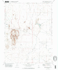
1971 Map of Smelter Knolls East
USGS Topo · Published 1974About this map
The Topaz Camp (Site) in Millard County marks a significant historical location within this 1970s landscape, providing a geographic record of the site decades after its wartime use. The surrounding desert environment is defined by the Old River Bed Depression, an ancient watercourse that cuts through the arid basin. To the west, the volcanic landforms of Smelter Knolls rise sharply from the valley floor, accompanied by the distinctive Hogs Back ridge. Water management is central to the area's utility, evidenced by the Abraham Canal, Abraham Reservoir, and the Little Drum Reservoir. The map also captures several industrial and agricultural features, including a Storage Bin, multiple Mine sites, and a network of Jeep Trails that navigate the varied terrain of the Sevier Desert.
Find a feature on this map
15 named features on this map. Tap any name to fly to it.
Don’t see what you’re looking for? This feature index may not catch every label — zoom into the map to look around manually.
Map Details
Editions of this 1971 Smelter Knolls East Map
2 editions found
Other maps of this area

1885 · Sevier Desert
USGS Topo · 1:250,000

1953 · Delta
USGS Topo · 1:250,000

1958 · Delta
USGS Topo · 1:250,000

1962 · Delta
USGS Topo · 1:250,000

1962 · Delta
USGS Topo · 1:62,500

1971 · Smelter Knolls East
USGS Topo · 1:24,000

1971 · Baker Hot Springs
USGS Topo · 1:24,000

1971 · Clay Knoll
USGS Topo · 1:24,000

1971 · Drum Mts Well
USGS Topo · 1:24,000

1971 · Fumarole Butte
USGS Topo · 1:24,000