
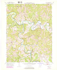
1952 Map of Claysville
USGS Topo · Published 1954About this map
The Licking River and its North Fork dominate this 1950s landscape, carving deep, winding loops through the borderlands of Bracken, Harrison, and Pendleton Counties. Small rural communities like Claysville and Milford serve as anchors for the surrounding farmsteads, connected by a network of narrow roads following the ridgelines and valley floors. Genealogy interests are well-served by the location of family-named landmarks such as Browning Corner and the nearby Browning Cem, alongside country congregations at Mt Gilead Ch and Barlow Ch. The terrain is characterized by intricate drainage systems, where numerous branches like Garrard Branch and Jackson Branch feed into the larger river system. This survey reflects the post-war rural character of Northern Kentucky before significant modern development, preserving the placement of homes, schools, and local cemeteries exactly as they stood during the early 1950s field check.
Find a feature on this map
28 named features on this map. Tap any name to fly to it.
Don’t see what you’re looking for? This feature index may not catch every label — zoom into the map to look around manually.
Map Details
Editions of this 1952 Claysville Map
2 editions found
Other maps of this area

1929 · Cynthiana
USGS Topo · 1:48,000

1930 · Falmouth
USGS Topo · 1:48,000

1934 · Cynthiana
USGS Topo · 1:62,500

1936 · Falmouth
USGS Topo · 1:62,500

1952 · Mount Olivet
USGS Topo · 1:24,000

1952 · Piqua
USGS Topo · 1:24,000

1952 · Berlin
USGS Topo · 1:24,000

1952 · Shady Nook
USGS Topo · 1:24,000

1952 · Brooksville
USGS Topo · 1:24,000

1953 · Kelat
USGS Topo · 1:24,000