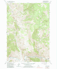
1963 Map of Clayton
USGS Topo · Published 1965About this map
The settlement of Clayton serves as the focal point for this mid-century look at Idaho's mining history along the Salmon River. The landscape is defined by industrial activity and rugged natural features, prominently featuring the Clayton Mine with its associated Tramway and Tailings Pond. Further north, the Redbird Mine and South Butte Mine underscore the area's extraction-based economy. Beyond the river valley, the terrain rises into the Challis National Forest, where peaks like Saturday Mtn and South Butte overlook a network of watercourses including Kinnikinic Creek and Squaw Creek. Infrastructure of the era is captured through the Kinnikinic Aqueduct and various Jeep Trails that provide access to the steep Custer County backcountry. Notable natural sites like Sullivan Hot Springs offer a glimpse into the geothermal activity present along the river's path.
Find a feature on this map
38 named features on this map. Tap any name to fly to it.
Don’t see what you’re looking for? This feature index may not catch every label — zoom into the map to look around manually.
Map Details
Editions of this 1963 Clayton Map
2 editions found

Other maps of this area

1919 · Custer
USGS Topo · 1:125,000

1922 · Custer
USGS Topo · 1:125,000

1929 · Bayhorse
USGS Topo · 1:125,000

1957 · Challis
USGS Topo · 1:250,000

1960 · Challis
USGS Topo · 1:250,000

1963 · Challis
USGS Topo · 1:250,000

1963 · Bald Mountain
USGS Topo · 1:24,000

1963 · Bayhorse Lake
USGS Topo · 1:24,000
1963 · Elevenmile Creek
USGS Topo · 1:24,000

1963 · Bayhorse
USGS Topo · 1:24,000