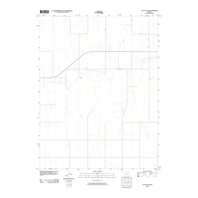
2009 Map of Clayton SW
USGS Topo · Published 2009About this map
The North Fork Solomon River meanders across this rural landscape, carving a subtle valley through the high plains of Decatur County. This 2009 survey highlights a classic Western Kansas grid system where infrastructure is defined by its utility and agricultural layout. The drainage of Spring Creek feeds into the river system, shaping the local topography while county roads like RD B B, RD D D, and RD W-15 mark the section lines. This document captures the agrarian character of the High Plains before modern industrial shifts, showing a terrain largely dedicated to broad-acre farming and water management in a semi-arid environment.
Find a feature on this map
6 named features on this map. Tap any name to fly to it.
Don’t see what you’re looking for? This feature index may not catch every label — zoom into the map to look around manually.
Map Details
Editions of this 2009 Clayton SW Map
This is the sole edition of this map. No revisions or reprints were ever made.
Other maps of this area

1954 · Goodland
USGS Topo · 1:250,000

1956 · Goodland
USGS Topo · 1:250,000

1957 · Goodland
USGS Topo · 1:250,000

1978 · Clayton SW
USGS Topo · 1:24,000

1978 · Clayton
USGS Topo · 1:24,000
1978 · Jennings
USGS Topo · 1:24,000

1978 · Allison
USGS Topo · 1:24,000

1978 · Lenora West
USGS Topo · 1:24,000
1978 · Clayton NE
USGS Topo · 1:24,000

1979 · Lucerne
USGS Topo · 1:24,000