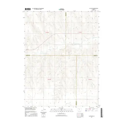
2015 Map of Clayton SW
USGS Topo · Published 2015About this map
N Fork Solomon River meanders across this rural landscape where four Kansas counties—Decatur, Norton, Sheridan, and Graham—meet in a distinctive jurisdictional intersection. This high plains terrain is defined by its sectional grid, with a network of local thoroughfares such as RD B B and RD D D providing access to the upland drainage basins. Near the western edge of the quadrangle, Allison Cem serves as a significant landmark for those tracing local family histories and early settlement patterns in this part of Decatur County. The hydrology is dominated by the river and its tributaries, including Spring Cr, which cut through the open country. The map clearly delineates the township and range boundaries, including t5s r26w and t6s r25w, offering a precise view of the land division and rural infrastructure as it existed in the mid-2010s.
Find a feature on this map
21 named features on this map. Tap any name to fly to it.
Don’t see what you’re looking for? This feature index may not catch every label — zoom into the map to look around manually.
Map Details
Editions of this 2015 Clayton SW Map
This is the sole edition of this map. No revisions or reprints were ever made.
Other maps of this area

1954 · Goodland
USGS Topo · 1:250,000

1956 · Goodland
USGS Topo · 1:250,000

1957 · Goodland
USGS Topo · 1:250,000

1978 · Clayton SW
USGS Topo · 1:24,000

1978 · Clayton
USGS Topo · 1:24,000
1978 · Jennings
USGS Topo · 1:24,000

1978 · Allison
USGS Topo · 1:24,000

1978 · Lenora West
USGS Topo · 1:24,000
1978 · Clayton NE
USGS Topo · 1:24,000

1979 · Lucerne
USGS Topo · 1:24,000