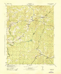
1944 Map of Clayville
USGS Topo · Published 1944About this map
The Appomattox River winds along the western edge of this mid-century landscape, marking the boundary between Chesterfield, Powhatan, and Amelia counties. This period is defined by a rural network of small agricultural hubs connected by the Southern railroad, which passes through Moseley, Dorset, and Clayville. The prominence of community infrastructure, such as Grange Hall High School and several local congregations like Skinquarter Church and Bethany Church, points to a densely populated rural society before the mid-century transition to larger regional centers.
Find a feature on this map
29 named features on this map. Tap any name to fly to it.
Don’t see what you’re looking for? This feature index may not catch every label — zoom into the map to look around manually.
Map Details
Editions of this 1944 Clayville Map
This is the sole edition of this map. No revisions or reprints were ever made.
Other maps of this area

1890 · Goochland
USGS Topo · 1:125,000

1892 · Goochland
USGS Topo · 1:125,000

1897 · Amelia
USGS Topo · 1:125,000

1943 · Fine Creek Mills
USGS Topo · 1:31,680

1943 · Powhatan
USGS Topo · 1:31,680

1943 · Amelia
USGS Topo · 1:31,680

1943 · Goodes Bridge
USGS Topo · 1:31,680

1943 · Hallsboro
USGS Topo · 1:31,680

1943 · Clayville
USGS Topo · 1:24,000

1943 · Midlothian
USGS Topo · 1:24,000