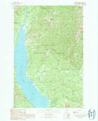
1989 Map of Cle Elum Lake
USGS Topo · Published 1989About this map
Cle Elum Lake serves as the dominant feature of this central Washington landscape, bordered by the dense reaches of the Wenatchee National Forest. The map illustrates the varied shoreline along the eastern bank, including recreational access points like the Wish Poosh Campground and a dedicated Boat Ramp near the mouth of Newport Creek. To the south, the small community of Lakedale marks the transition from the lake's edge to the rising elevations of Cle Elum Ridge.
Find a feature on this map
32 named features on this map. Tap any name to fly to it.
Don’t see what you’re looking for? This feature index may not catch every label — zoom into the map to look around manually.
Map Details
Editions of this 1989 Cle Elum Lake Map
2 editions found
Other maps of this area

1897 · Mount Stuart
USGS Topo · 1:125,000

1901 · Snoqualmie Pass
USGS Topo · 1:125,000

1902 · Mount Stuart
USGS Topo · 1:125,000

1903 · Snoqualmie
USGS Topo · 1:125,000

1957 · Wenatchee
USGS Topo · 1:250,000

1958 · Cle Elum
USGS Topo · 1:62,500

1961 · Mount Stuart
USGS Topo · 1:62,500

1961 · Easton
USGS Topo · 1:62,500

1961 · Kachess Lake
USGS Topo · 1:62,500

1975 · Snoqualmie Pass
USGS Topo · 1:100,000