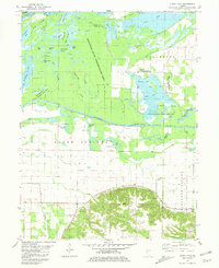
1981 Map of Clear Lake
USGS Topo · Published 1981About this map
The Sangamon River carves a complex course through this portion of Cass County, creating a mosaic of backwaters, sloughs, and lakes. The Sanganois State Conservation Area dominates the northern half of the landscape, protecting a labyrinthine network of water bodies such as Eagle Lake, Chain Lake, and Crane Lake. This intricate wetland environment, including Cuba Island and Knapps Island, underscores the historical importance of the river’s natural flood cycle before modern hydrologic modifications changed the surrounding Illinois plains.
Find a feature on this map
52 named features on this map. Tap any name to fly to it.
Don’t see what you’re looking for? This feature index may not catch every label — zoom into the map to look around manually.
Map Details
Editions of this 1981 Clear Lake Map
This is the sole edition of this map. No revisions or reprints were ever made.
Other maps of this area

1926 · Beardstown
USGS Topo · 1:62,500

1929 · Arenzville
USGS Topo · 1:62,500

1930 · Chandlerville
USGS Topo · 1:62,500

1932 · Arenzville
USGS Topo · 1:62,500

1932 · Chandlerville
USGS Topo · 1:62,500

1932 · Virginia
USGS Topo · 1:62,500

1936 · Virginia
USGS Topo · 1:62,500

1944 · Beardstown
USGS Topo · 1:62,500

1948 · Quincy
USGS Topo · 1:250,000

1956 · Quincy
USGS Topo · 1:250,000