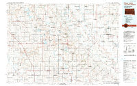
1985 Map of Clear Lake
USGS Topo · Published 1990About this map
The glacial landscape of the Coteau des Prairies defines this borderland between eastern South Dakota and western Minnesota. High points like Buffalo Hill and Antelope Hills overlook a prairie dotted with dozens of water bodies, including Lake Alice, Fish Lake, and the namesake Clear Lake. The region’s hydrology is notably split, with the Big Sioux River flowing south while the Lac qui Parle River and Yellow Medicine River drain toward the northeast.
Find a feature on this map
147 named features on this map. Tap any name to fly to it.
Don’t see what you’re looking for? This feature index may not catch every label — zoom into the map to look around manually.
Map Details
Editions of this 1985 Clear Lake Map
2 editions found

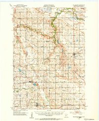
Other maps of this area
1953 · Bellingham
USGS Topo · 1:62,500

1953 · Milbank
USGS Topo · 1:250,000

1953 · Watertown
USGS Topo · 1:250,000

1953 · New Ulm
USGS Topo · 1:250,000

1953 · Saint Cloud
USGS Topo · 1:250,000

1957 · Saint Cloud
USGS Topo · 1:250,000

1957 · New Ulm
USGS Topo · 1:250,000

1958 · New Ulm
USGS Topo · 1:250,000

1958 · Milbank
USGS Topo · 1:250,000

1958 · Watertown
USGS Topo · 1:250,000