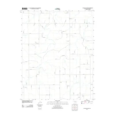
2012 Map of Clear Lake NW
USGS Topo · Published 2012About this map
Clear Cr and its meandering tributaries dominate this section of the Oklahoma Panhandle, illustrating a landscape defined by intermittent drainage and the structured section-line road grid typical of Beaver County. The terrain is shaped by the winding courses of Cottonwood Cr, Camp Cr, and Duck Pond Cr, which cut through the high plains. The transport network is strictly geometric, primarily composed of dirt and gravel roads such as EW19 Rd and N1420 Rd that follow the township and range lines. While largely devoid of concentrated settlements, the area's geography is essential for understanding the ranching and agricultural patterns of the early 21st century, where water access remains the primary driver of land use and development.
Find a feature on this map
62 named features on this map. Tap any name to fly to it.
Don’t see what you’re looking for? This feature index may not catch every label — zoom into the map to look around manually.
Map Details
Editions of this 2012 Clear Lake NW Map
This is the sole edition of this map. No revisions or reprints were ever made.
Other maps of this area

1954 · Perryton
USGS Topo · 1:250,000

1958 · Perryton
USGS Topo · 1:250,000

1970 · Mocane SE
USGS Topo · 1:24,000

1971 · Clear Lake NW
USGS Topo · 1:24,000

1971 · Clear Lake SW
USGS Topo · 1:24,000

1971 · Clear Lake
USGS Topo · 1:24,000

1971 · Clear Lake SE
USGS Topo · 1:24,000
1971 · Mocane SW
USGS Topo · 1:24,000

1973 · Balko NE
USGS Topo · 1:24,000

1973 · Elmwood
USGS Topo · 1:24,000