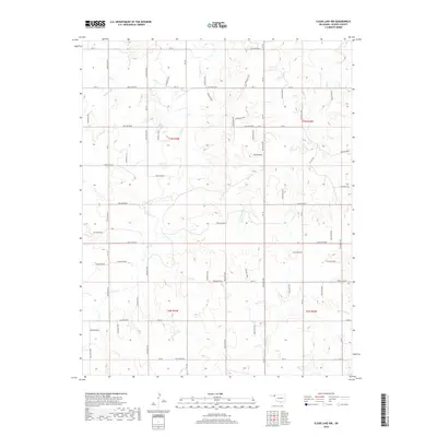
2018 Map of Clear Lake NW
USGS Topo · Published 2018About this map
The High Plains of Beaver County are defined by a complex network of drainage channels and intermittent streams, most notably Cottonwood Cr and Clear Cr. This 2018 survey details the topographic transitions between the upland plateaus and the lower basins of Camp Cr and Duck Pond Cr. The landscape is methodically partitioned by an extensive system of local service roads and section lines, represented here by labels such as Hollow E0190 and Hollow N1440. While largely rural and open, the region's industrial footprint is clearly marked by the presence of Oil Fld Rd, signaling the local energy economy. These detailed contours illustrate the subtle but significant elevation changes across the Oklahoma Panhandle, where the land falls away into the various hollows and creek beds that provide the only major relief in the terrain.
Find a feature on this map
47 named features on this map. Tap any name to fly to it.
Don’t see what you’re looking for? This feature index may not catch every label — zoom into the map to look around manually.
Map Details
Editions of this 2018 Clear Lake NW Map
This is the sole edition of this map. No revisions or reprints were ever made.
Other maps of this area

1954 · Perryton
USGS Topo · 1:250,000

1958 · Perryton
USGS Topo · 1:250,000

1970 · Mocane SE
USGS Topo · 1:24,000

1971 · Clear Lake NW
USGS Topo · 1:24,000

1971 · Clear Lake SW
USGS Topo · 1:24,000

1971 · Clear Lake
USGS Topo · 1:24,000

1971 · Clear Lake SE
USGS Topo · 1:24,000
1971 · Mocane SW
USGS Topo · 1:24,000

1973 · Balko NE
USGS Topo · 1:24,000

1973 · Elmwood
USGS Topo · 1:24,000