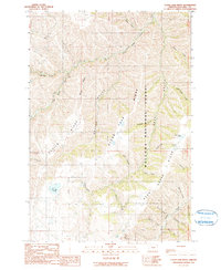
1990 Map of Clear Lake Ridge
USGS Topo · Published 1990About this map
Clear Lake Ridge and Devils Ridge dominate this high-elevation landscape within the Wallowa National Forest, where steep drainages and isolated water bodies define the remote terrain. The survey captures a network of creeks and gulches that feed into larger systems like Big Sheep Creek and Butte Creek. Significant water features such as Dead Horse Lake and Downey Lake serve as primary landmarks in a region largely devoid of permanent settlements or structures. The complex topography is further articulated by deep cuts like Horse Gulch and Bird Canyon, illustrating the erosive forces at work in the northeastern Oregon mountains. This provisional data reflects the area as it was field-checked in the late 1980s, preserving the nomenclature of the ridges and canyons used by foresters and backcountry travelers of the era.
Find a feature on this map
33 named features on this map. Tap any name to fly to it.
Don’t see what you’re looking for? This feature index may not catch every label — zoom into the map to look around manually.
Map Details
Editions of this 1990 Clear Lake Ridge Map
This is the sole edition of this map. No revisions or reprints were ever made.
Other maps of this area

1954 · Imnaha
USGS Topo · 1:62,500

1954 · Harl Butte
USGS Topo · 1:62,500

1955 · Grangeville
USGS Topo · 1:250,000

1957 · Joseph
USGS Topo · 1:62,500

1957 · Elk Mountain
USGS Topo · 1:62,500

1959 · Grangeville
USGS Topo · 1:250,000

1980 · Grangeville
USGS Topo · 1:100,000

1982 · Wallowa
USGS Topo · 1:100,000

1986 · Enterprise
USGS Topo · 1:100,000

1987 · Riggins
USGS Topo · 1:100,000