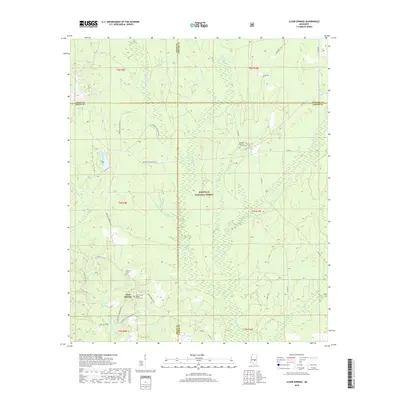
2018 Map of Clear Springs
USGS Topo · Published 2018About this map
Bienville National Forest dominates this central Mississippi landscape, where a dense network of creeks and branches feeds the local timberlands. The settlement of Clear Springs serves as a local focal point, characterized by its spiritual and community centers like the Clear Springs Baptist Church Cem. The map reveals a complex drainage pattern defined by Little Tallahala Cr, Ichusa Cr, and Quarterliah Cr, which meander through the forested sections. Family and local history are preserved in small clearings and burial grounds, including the Burnett Cem and Decedar Baptist Church Cem. A web of forest and county roads, such as Louin Pineville Rd and Sun Rd, provides the primary infrastructure through the wooded terrain of Scott, Newton, Smith, and Jasper counties. Marathon Lake offers a distinct water feature amidst the expansive greenery of the national forest.
Find a feature on this map
49 named features on this map. Tap any name to fly to it.
Don’t see what you’re looking for? This feature index may not catch every label — zoom into the map to look around manually.
Map Details
Editions of this 2018 Clear Springs Map
This is the sole edition of this map. No revisions or reprints were ever made.
Other maps of this area

1921 · Forest
USGS Topo · 1:48,000

1922 · Forest
USGS Topo · 1:62,500

1950 · Forest
USGS Topo · 1:62,500

1952 · Forest
USGS Topo · 1:62,500

1953 · Meridian
USGS Topo · 1:250,000

1957 · Meridian
USGS Topo · 1:250,000

1965 · Meridian
USGS Topo · 1:250,000

1966 · Newton
USGS Topo · 1:24,000

1968 · Clear Springs
USGS Topo · 1:24,000

1968 · Pineville
USGS Topo · 1:24,000