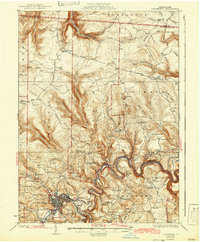
1932 Map of Clearfield
USGS Topo · Published 1942About this map
The Susquehanna River winds through a deeply dissected landscape in this early twentieth-century survey, anchoring the regional economy of Clearfield. The town's industrial and logistical importance is evident in the convergence of the Pennsylvania RR, the Buffalo Rochester and Pittsburgh RR, and the New York Central and Hudson River RR. Beyond the rail yards and riverside settlements like Shawville and Hyde, the map reveals a dense network of upland schools and churches that served isolated farming and timbering communities. Places such as Lecontes Mills and Gillingham sit amidst high ridges like Chestnut Ridge and Knobs. This survey preserves the location of numerous rural institutions, including the Mt Sinai Sch, Goshen Ch, and the Pleasant Hill Sch, many of which were central to the social fabric of Clearfield County before modern consolidation.
Find a feature on this map
91 named features on this map. Tap any name to fly to it.
Don’t see what you’re looking for? This feature index may not catch every label — zoom into the map to look around manually.
Map Details
Editions of this 1932 Clearfield Map
4 editions found
Other maps of this area

1903 · Curwensville
USGS Topo · 1:62,500

1903 · Houtzdale
USGS Topo · 1:62,500

1905 · Houtzdale
USGS Topo · 1:62,500

1922 · Philipsburg
USGS Topo · 1:62,500

1929 · Karthaus
USGS Topo · 1:62,500

1929 · Clearfield
USGS Topo · 1:48,000

1929 · Penfield
USGS Topo · 1:62,500

1932 · Clearfield
USGS Topo · 1:62,500

1932 · Penfield
USGS Topo · 1:62,500

1932 · Karthaus
USGS Topo · 1:62,500