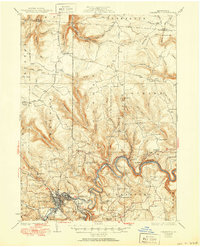
1932 Map of Clearfield
USGS Topo · Published 1951About this map
The West Branch Susquehanna River winds through a landscape of deep ridges and industrial development in this early 20th-century survey. The town of Clearfield serves as a central hub, where the Pa RR and New York Central RR facilitate movement through the river valley. Along the banks, smaller settlements like Shawville and Gray appear alongside infrastructure like the Clearfield Junction.
Find a feature on this map
97 named features on this map. Tap any name to fly to it.
Don’t see what you’re looking for? This feature index may not catch every label — zoom into the map to look around manually.
Map Details
Editions of this 1932 Clearfield Map
4 editions found
Other maps of this area

1903 · Curwensville
USGS Topo · 1:62,500

1903 · Houtzdale
USGS Topo · 1:62,500

1905 · Houtzdale
USGS Topo · 1:62,500

1922 · Philipsburg
USGS Topo · 1:62,500

1929 · Karthaus
USGS Topo · 1:62,500

1929 · Clearfield
USGS Topo · 1:48,000

1929 · Penfield
USGS Topo · 1:62,500

1932 · Clearfield
USGS Topo · 1:62,500

1932 · Penfield
USGS Topo · 1:62,500

1932 · Karthaus
USGS Topo · 1:62,500