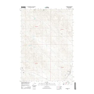
2015 Map of Clearmont
USGS Topo · Published 2015About this map
Clearmont sits at the confluence of several vital water systems in this 2015 high-plains survey of Sheridan County. The landscape is defined by an intricate network of drainage draws and ranch-style water management, visible through numerous named catchments such as the Robert Black Stump Reservoir and the Snider Number 1 Town Draw Reservoir. The town itself is oriented around Clear Creek, where local infrastructure like Water St and Devon St provides a rare concentrated point of settlement amidst the vast surrounding drainage basins. Ranching history and land use are evident in the naming of features like the Rate and Huson Reservoir and Pence Reservoir, while the seasonal hydrology of the region is traced through the winding paths of Whitmeyer Cr, Pinhead Cr, and Lone Tree Cr. This terrain is deeply marked by erosional features such as Dead Mans Draw and Sand Draw, illustrating the high-desert character of northern Wyoming.
Find a feature on this map
27 named features on this map. Tap any name to fly to it.
Don’t see what you’re looking for? This feature index may not catch every label — zoom into the map to look around manually.
Map Details
Editions of this 2015 Clearmont Map
This is the sole edition of this map. No revisions or reprints were ever made.
Other maps of this area

1909 · Sheridan
USGS Topo · 1:125,000

1911 · Sheridan
USGS Topo · 1:125,000

1955 · Sheridan
USGS Topo · 1:250,000

1958 · Sheridan
USGS Topo · 1:250,000

1962 · Sheridan
USGS Topo · 1:250,000
1970 · Ulm
USGS Topo · 1:24,000
1970 · Ucross
USGS Topo · 1:24,000
1970 · S R Springs
USGS Topo · 1:24,000
1971 · Shuler Draw
USGS Topo · 1:24,000
1971 · Clearmont
USGS Topo · 1:24,000