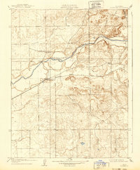
1909 Map of Clements
USGS Topo · Published 1939About this map
Clements serves as a primary rail and agricultural hub along the Southern Pacific R R at the turn of the century. This landscape, surveyed by R.B. Marshall and his team, reveals the early development of the San Joaquin valley as it meets the rising foothills. The Mokelumne River winds through the northern portion of the sheet, joined by smaller drainages like Coyote Creek and Murphy Creek. The distribution of rural education is evident through the presence of Justice School and Washington School, which anchored these early farming communities. Just north of the river, the small settlement of Dogtown sits near the crossing to Amador Co, highlighting the historic connections between these gold-country counties. The terrain transitions into Valley Springs, with the contour lines beginning to tighten as the map moves toward the eastern uplands.
Find a feature on this map
12 named features on this map. Tap any name to fly to it.
Don’t see what you’re looking for? This feature index may not catch every label — zoom into the map to look around manually.
Map Details
Editions of this 1909 Clements Map
2 editions found

Other maps of this area

1889 · Jackson
USGS Topo · 1:125,000

1892 · Jackson
USGS Topo · 1:125,000

1894 · Lodi
USGS Topo · 1:125,000

1897 · Jackson
USGS Topo · 1:125,000

1902 · Jackson
USGS Topo · 1:125,000

1908 · Waterloo
USGS Topo · 1:31,680

1908 · Linden
USGS Topo · 1:31,680

1908 · Lockeford
USGS Topo · 1:31,680

1909 · Clay
USGS Topo · 1:31,680

1909 · Goose Creek
USGS Topo · 1:31,680