
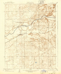
1909 Map of Clements
USGS Topo · Published 1909About this map
Clements serves as a focal point in this 1907 survey of the northern Central Valley, where the Southern Pacific R R cuts across the landscape toward the foothills. The Valley Springs Branch follows the southern bank of the Mokelumne River, a waterway that defined the early agrarian and industrial potential of San Joaquin County. Evidence of early community structure is preserved in labels for rural education centers such as Justice School and Washington School, which supported the surrounding farming population.
Find a feature on this map
14 named features on this map. Tap any name to fly to it.
Don’t see what you’re looking for? This feature index may not catch every label — zoom into the map to look around manually.
Map Details
Editions of this 1909 Clements Map
2 editions found
Other maps of this area

1889 · Jackson
USGS Topo · 1:125,000

1892 · Jackson
USGS Topo · 1:125,000

1894 · Lodi
USGS Topo · 1:125,000

1897 · Jackson
USGS Topo · 1:125,000

1902 · Jackson
USGS Topo · 1:125,000

1908 · Waterloo
USGS Topo · 1:31,680

1908 · Linden
USGS Topo · 1:31,680

1908 · Lockeford
USGS Topo · 1:31,680

1909 · Clay
USGS Topo · 1:31,680

1909 · Goose Creek
USGS Topo · 1:31,680