1952 Map of Clements
USGS Topo · Published 1954About this map
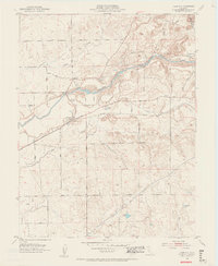
Clements and the neighboring settlement of Dogtown sit at a geographic intersection where the Southern Pacific railroad meets the winding course of the Mokelumne River. The landscape here is defined by significant industrial transformation, visible in the extensive Dredge Tailings that bank the river, evidence of intensive resource extraction in the San Joaquin valley. These remnants of dredging operations sit in contrast to the rural road network, which includes historic thoroughfares like Liberty Road, Jahant Road, and Sargent Road.
Find a feature on this map
21 named features on this map. Tap any name to fly to it.
Don’t see what you’re looking for? This feature index may not catch every label — zoom into the map to look around manually.
Map Details
Editions of this 1952 Clements Map
2 editions found
Historical Maps of Clements Through Time
96 maps found

1909 Clements
San Joaquin County, CA

1910 Bouldin
San Joaquin County, CA

1910 Castle
San Joaquin County, CA

1910 Headreach
San Joaquin County, CA

1910 New Hope
San Joaquin County, CA

1913 Holt
San Joaquin County, CA

1914 Avena
San Joaquin County, CA

1914 Bethany
San Joaquin County, CA

1914 Burnham
San Joaquin County, CA

1914 Union Island
San Joaquin County, CA

1915 Thalheim
San Joaquin County, CA

1915 Trigo
San Joaquin County, CA

1915 Vernalis
San Joaquin County, CA

1922 Carbona
San Joaquin County, CA

1939 Bellota
San Joaquin County, CA

1942 Bellota
San Joaquin County, CA

1942 Carbona
San Joaquin County, CA

1952 Avena
San Joaquin County, CA

1952 Bethany
San Joaquin County, CA

1952 Bouldin Island
San Joaquin County, CA

1952 Clements
San Joaquin County, CA

1952 Holt
San Joaquin County, CA

1952 New Hope
San Joaquin County, CA

1952 Stockton East
San Joaquin County, CA

1952 Stockton West
San Joaquin County, CA

1952 Union Island
San Joaquin County, CA

1952 Vernalis
San Joaquin County, CA

1953 Lodi North
San Joaquin County, CA

1953 Lodi South
San Joaquin County, CA

1955 Lone Tree Creek
San Joaquin County, CA

1962 Valley Springs SW
San Joaquin County, CA

1968 Clements
San Joaquin County, CA

1968 Lodi North
San Joaquin County, CA

1968 Lodi South
San Joaquin County, CA

1968 Stockton East
San Joaquin County, CA

1968 Stockton West
San Joaquin County, CA

1969 Vernalis
San Joaquin County, CA

1978 Bouldin Island
San Joaquin County, CA

1978 Clifton Court Forebay
San Joaquin County, CA

1978 Holt
San Joaquin County, CA

1978 Union Island
San Joaquin County, CA

1991 Vernalis
San Joaquin County, CA

1997 Bouldin Island
San Joaquin County, CA

1998 Valley Springs SW
San Joaquin County, CA

2012 Avena
San Joaquin County, CA

2012 Bouldin Island
San Joaquin County, CA

2012 Clements
San Joaquin County, CA

2012 Clifton Court Forebay
San Joaquin County, CA

2012 Holt
San Joaquin County, CA

2012 Lodi North
San Joaquin County, CA

2012 Lodi South
San Joaquin County, CA

2012 Lone Tree Creek
San Joaquin County, CA

2012 Stockton East
San Joaquin County, CA

2012 Stockton West
San Joaquin County, CA

2012 Union Island
San Joaquin County, CA

2012 Valley Springs SW
San Joaquin County, CA

2012 Vernalis
San Joaquin County, CA

2015 Avena
San Joaquin County, CA

2015 Bouldin Island
San Joaquin County, CA

2015 Clements
San Joaquin County, CA

2015 Clifton Court Forebay
San Joaquin County, CA

2015 Holt
San Joaquin County, CA

2015 Lodi North
San Joaquin County, CA

2015 Lodi South
San Joaquin County, CA

2015 Lone Tree Creek
San Joaquin County, CA

2015 Stockton East
San Joaquin County, CA

2015 Stockton West
San Joaquin County, CA

2015 Union Island
San Joaquin County, CA

2015 Valley Springs SW
San Joaquin County, CA

2015 Vernalis
San Joaquin County, CA

2018 Avena
San Joaquin County, CA

2018 Bouldin Island
San Joaquin County, CA

2018 Clements
San Joaquin County, CA

2018 Clifton Court Forebay
San Joaquin County, CA

2018 Holt
San Joaquin County, CA

2018 Lodi North
San Joaquin County, CA

2018 Lodi South
San Joaquin County, CA

2018 Lone Tree Creek
San Joaquin County, CA

2018 Stockton East
San Joaquin County, CA

2018 Stockton West
San Joaquin County, CA

2018 Union Island
San Joaquin County, CA

2018 Valley Springs SW
San Joaquin County, CA

2018 Vernalis
San Joaquin County, CA

2021 Avena
San Joaquin County, CA

2021 Bouldin Island
San Joaquin County, CA

2021 Clifton Court Forebay
San Joaquin County, CA

2021 Holt
San Joaquin County, CA

2021 Lodi North
San Joaquin County, CA

2021 Lodi South
San Joaquin County, CA

2021 Lone Tree Creek
San Joaquin County, CA

2021 Stockton East
San Joaquin County, CA

2021 Stockton West
San Joaquin County, CA

2021 Union Island
San Joaquin County, CA

2021 Valley Springs SW
San Joaquin County, CA

2021 Vernalis
San Joaquin County, CA

2022 Clements
San Joaquin County, CA