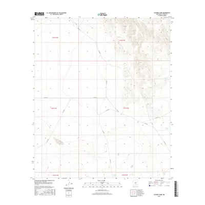
2017 Map of Cleones Tank
USGS Topo · Published 2017About this map
Cleones Tank and several other named water catchments dot this high-desert landscape in eastern Otero County. The terrain is defined by a series of north-south ridges and draws, with elevation contours illustrating the complex drainage patterns of the region. A network of county roads, including Co Rd E001 and Co Rd F052, provides access through the various sections of the Public Land Survey System, which is clearly delineated across several townships. The infrastructure recorded here, such as Number 11 Tank and North Tank, reflects the vital importance of water management in this arid environment. This 2017 survey serves as a detailed record of the roads and landmarks used by local ranchers and land managers navigating the topography of the Sacramento Mountains foothills.
Find a feature on this map
19 named features on this map. Tap any name to fly to it.
Don’t see what you’re looking for? This feature index may not catch every label — zoom into the map to look around manually.
Map Details
Editions of this 2017 Cleones Tank Map
This is the sole edition of this map. No revisions or reprints were ever made.
Other maps of this area

1954 · Carlsbad
USGS Topo · 1:250,000

1958 · Carlsbad
USGS Topo · 1:250,000

1959 · Alamo Mountain
USGS Topo · 1:62,500
1963 · Cornucopia Ranch SE
USGS Topo · 1:24,000

1963 · Indian Draw
USGS Topo · 1:24,000

1963 · Cleones Tank
USGS Topo · 1:24,000

1970 · Shiloh Hills
USGS Topo · 1:24,000
1970 · Van Winkle Lake
USGS Topo · 1:24,000

1975 · Alamo Mountain NE
USGS Topo · 1:24,000

1979 · Crow Flats
USGS Topo · 1:100,000