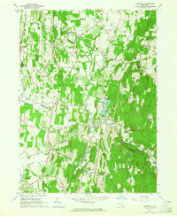
1963 Map of Clermont
USGS Topo · Published 1964About this map
Roe Liff Jansen Kill carves a winding path through this early 1960s landscape, marking the transition between the rolling uplands of Livingston and Clermont. The map captures a rural economy defined by scattered hamlets and local industry, such as Bingham Mills and Red Hook Mills, which were historically tied to the area's many waterways. The New York Central Railroad corridor and the Taconic State Parkway facilitate movement across the Columbia and Dutchess County line, connecting local centers like Upper Red Hook and Nevis to the broader Hudson Valley.
Find a feature on this map
46 named features on this map. Tap any name to fly to it.
Don’t see what you’re looking for? This feature index may not catch every label — zoom into the map to look around manually.
Map Details
Editions of this 1963 Clermont Map
4 editions found
Other maps of this area

1895 · Catskill
USGS Topo · 1:62,500

1898 · Rhinebeck
USGS Topo · 1:62,500

1899 · Millbrook
USGS Topo · 1:62,500

1902 · Millbrook
USGS Topo · 1:62,500

1902 · Copake
USGS Topo · 1:62,500

1904 · Copake
USGS Topo · 1:62,500

1934 · Rhinebeck
USGS Topo · 1:48,000

1934 · Catskill
USGS Topo · 1:62,500

1938 · Catskill
USGS Topo · 1:62,500

1939 · Rhinebeck
USGS Topo · 1:62,500